UNITED STATES – The Weather Prediction Center released its seasonal precipitation outlook for July through September, giving forecasters and residents across the country their first detailed look at what the coming summer months might bring in terms of rainfall. The outlook, issued June 18 and valid for the July-August-September stretch, arrives at a time when meteorologists are closely tracking a broader climate pattern shift toward El Niño, a transition that tends to reshape rainfall patterns across large portions of the United States.
While seasonal outlooks of this kind are generally treated with some caution within the weather community, given how far out they look and how much can change in the interim, this particular forecast carries added weight because it lines up closely with the ongoing move toward El Niño conditions. That alignment is giving forecasters more confidence than usual in some of the regional trends showing up on the map.
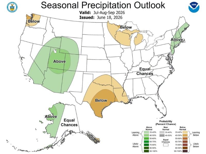
Thermal Highs and a More Active Subtropical Jet Set the Stage
According to the outlook, the setup heading into July centers around thermal highs building near the Baja California region. These high pressure systems are expected to oscillate east and west over the coming weeks, shifting position depending on a range of atmospheric factors that will continue to evolve as summer progresses.
That thermal high is expected to pair with a more active subtropical jet stream this year, a combination forecasters say should help energize the monsoon season across the Southwest. The subtropical jet plays a key role in steering moisture into the region, and a more active pattern typically translates into a stronger, more reliable monsoon season for areas that depend heavily on summer rainfall.
Four Corners Region Expected to See Above Average Rainfall
The direct result of this setup is a forecast calling for above average precipitation across the Four Corners region, an area where Arizona, New Mexico, Utah, and Colorado all meet. The above average designation extends into parts of Colorado as well, meaning residents and water managers in that region could see a wetter than typical summer if the outlook holds.
For a region that often depends on monsoon moisture to help offset dry conditions carried over from spring, a stronger monsoon season tied to El Niño could provide meaningful relief, particularly for areas that have dealt with persistent dryness in recent years.
Mixed Picture Across the Rest of the Country
Beyond the Southwest, the national map tells a more varied story. Pockets of the Pacific Northwest and the Upper Midwest are leaning toward below average precipitation for the summer period, as is a stretch of Texas extending down toward the Gulf Coast. On the other end of the spectrum, parts of the Northeast, including areas of New England, along with portions of Alaska, are trending toward above average rainfall over the same stretch.
A large share of the country, including much of the Southeast and the broader East Coast corridor, falls into the equal chances category on the outlook map. That designation means forecasters don’t see a strong enough signal in either direction to lean toward above or below normal conditions, leaving those areas essentially a toss-up heading into the summer.
What This Means Going Forward
Seasonal outlooks like this one are meant to offer a broad directional sense of what’s coming rather than a precise forecast, and conditions can and often do shift as summer unfolds. Even so, the alignment between this outlook and the larger El Niño pattern is giving forecasters a bit more confidence in the Southwest monsoon signal specifically, even as much of the rest of the country remains harder to call this far out.
Stay updated for the latest weather updates as this story develops.
Leave a Reply