ILLINOIS – Forecasters are keeping a close watch on Sunday as the next strong storm system moves into Illinois, though early indications suggest this round won’t be as significant as the past few weather events to hit the state. Confidence in the exact details remains low at this point, with high model variance making it difficult to pin down specifics so far out.
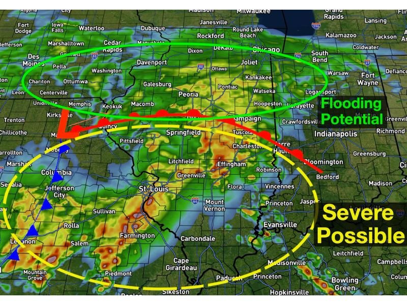
Meteorologists currently believe the state will see two distinct impact zones once the system arrives. Northern and north central Illinois, the first region, is expected to see heavy rain with an axis of two to four inches likely somewhere in the area. Given how much rain the region has already absorbed recently, additional flooding is considered likely.
Severe Storm Risk Centered South of I-72
The second region of concern covers south central and southern Illinois, where a few severe storms are possible. Forecasters say there are still significant questions surrounding atmospheric destabilization, leaving them without firm confidence on exactly where the highest risk will set up. Current thinking points to an area generally south of Interstate 72, with tornadoes and strong winds identified as the primary hazards to watch. Another day of data is expected to help narrow down the details.
Rain Timing Pushes Across the State Through Sunday
Rain is expected to begin moving across central Illinois by sunrise Sunday, spreading to cover the rest of the state by lunchtime and continuing into the evening hours. Severe weather timing in the southern portion of the state is expected to run from roughly 1 p.m. to 8 p.m.
Stay updated for the latest weather updates as this story develops.
Leave a Reply