ILLINOIS — A new storm system is set to move into Illinois this Sunday, bringing a lower-end severe weather threat alongside a more significant flash flooding concern, as already saturated soil faces the potential for an additional 2 to 4 inches of rainfall north of the storm’s track.
Flooding, Not Severe Weather, the Primary Threat This Time
Forecasters say this system will not be as strong as the previous severe weather event, but flooding has emerged as the greater concern. The region has already received 1 to 4 inches of rain in the prior day and 3 to 8 inches over the past week, leaving soils heavily saturated ahead of this next round.
Severe Risk Concentrated From Quincy Through Champaign South
A severe weather potential does exist with this system, supported by decent low-level shear, high moisture, and moderate instability. The greater risk is expected south of the warm front and near the triple point of low pressure. The system is forecast to track through north central Illinois, placing the severe risk zone generally from Quincy to Champaign and points south. Primary hazards include:
- A few tornadoes
- Strong wind gusts
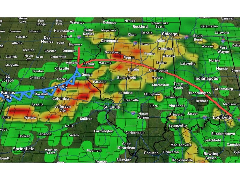
Storm Track Pushes From Northwest Missouri Through Southern Indiana
Forecast track data shows the system’s low pressure path moving from near the Iowa/Missouri border, through Quincy and Macomb, continuing east toward Peoria, Champaign, Indianapolis, and Bloomington, before exiting toward Louisville.
Timing: Rain Arrives Sunday Morning, Storms Develop by Afternoon
| Timeframe | Activity |
|---|---|
| Sunday Morning | Rain pushes into northern and central Illinois |
| Sunday Afternoon | Storms develop and move into south central and southern Illinois |
| Sunday Evening | System exits the state |
| Monday | Drying out begins |
Rainfall Totals Expected to Reach 2 to 4 Inches North of Track
Areas positioned north of the storm’s track are expected to see the heaviest rainfall, with totals generally ranging from 2 to 4 inches, compounding flood concerns given the already saturated ground conditions across the state.
Cold Front Behind System to Bring Temporary Break From Active Pattern
Following this system, a cold front is expected to move through, providing a lower ceiling on storm chances and a break from the recent stretch of active weather. Temperatures are expected to turn chilly at times heading into next week as the pattern calms.
Stay tuned for further updates as this system continues to develop heading into the weekend.
Leave a Reply