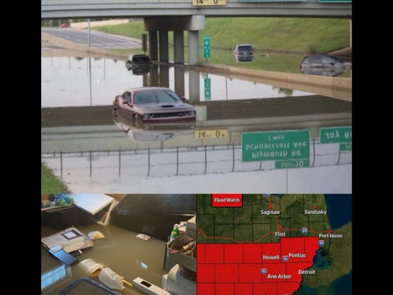
DETROIT, Michigan — A Flood Watch is in effect across Metro Detroit today as heavy rain and thunderstorms move into southeastern Michigan, raising concerns about flash flooding, water-covered roads, and travel disruptions through late tonight.
Forecasters warn that several rounds of rain and thunderstorms could impact the region, with some communities receiving 1 to 2 inches of rainfall and isolated locations potentially seeing more than 3 inches in a short period.
Flood Watch Covers Several Metro Detroit Counties
The Flood Watch includes Wayne, Oakland, Macomb, Washtenaw, Livingston, Monroe, and Lenawee counties.
Weather officials say the greatest flooding threat will occur in low-lying areas, locations with poor drainage, and urban communities where heavy rainfall can quickly overwhelm stormwater systems.
Residents living near creeks, streams, and flood-prone roadways should remain alert for rapidly changing conditions throughout the day and evening.
Heavy Rainfall Could Lead to Localized Flooding
Meteorologists expect thunderstorms to produce periods of intense rainfall capable of causing localized flooding.
Roadways, underpasses, parking lots, and areas that have experienced flooding during previous storms may become hazardous if rainfall rates increase.
Even if flooding remains localized, heavy downpours can create dangerous driving conditions by reducing visibility and causing water to accumulate on road surfaces.
Drivers Urged to Avoid Flooded Roads
Officials are encouraging motorists to use extra caution while traveling during the Flood Watch period.
Drivers should never attempt to drive through flooded roadways, as water depth can be difficult to judge and conditions may deteriorate quickly.
Travel delays are possible across portions of Metro Detroit as thunderstorms move through the region and create temporary flooding concerns.
Thunderstorms May Bring Additional Hazards
In addition to heavy rainfall, some storms may produce frequent lightning, gusty winds, and brief periods of severe weather.
Residents are encouraged to monitor local forecasts, weather alerts, and emergency notifications throughout the day as storm activity develops.
Those with outdoor plans should be prepared to seek shelter quickly if thunderstorms approach their location.
What Residents Should Do
Emergency officials recommend residents:
- Monitor weather alerts throughout the day.
- Avoid flooded roads and standing water.
- Secure outdoor items that could be affected by strong winds.
- Allow extra travel time during periods of heavy rainfall.
- Have multiple ways to receive weather warnings and emergency information.
Weather conditions are expected to remain active through tonight, and additional alerts may be issued if flooding or severe thunderstorms become more widespread.
Stay Updated
For the latest weather alerts, breaking news, and community updates, visit Floridaing.com and stay informed about conditions affecting your area.
Leave a Reply